
World Regions According to Google

This project came to me from sheer curiosity a while back.
I had to look up some quick stuff about some countries, and I noticed that in Google’s search engine France was labelled as a “Country in Europe”, but Spain as simply a “Country”.

So I decided to check what region each country was labelled as being in when looked up in google (or if they were labelled at all), and plot them on a map! And the results were actually very interesting, especially for being such a simple project.
All countries are either labelled as being in of one of eighteen regions or “Unlabelled”, which are the ones that simply show up as “Country”, and these are shown in a dark grey.
With the exception of Vatican City, only UN-recognized countries are labelled at all, with non-UN-recognized states not being labelled with anything, not even “Country”, and these are shown in a light grey.
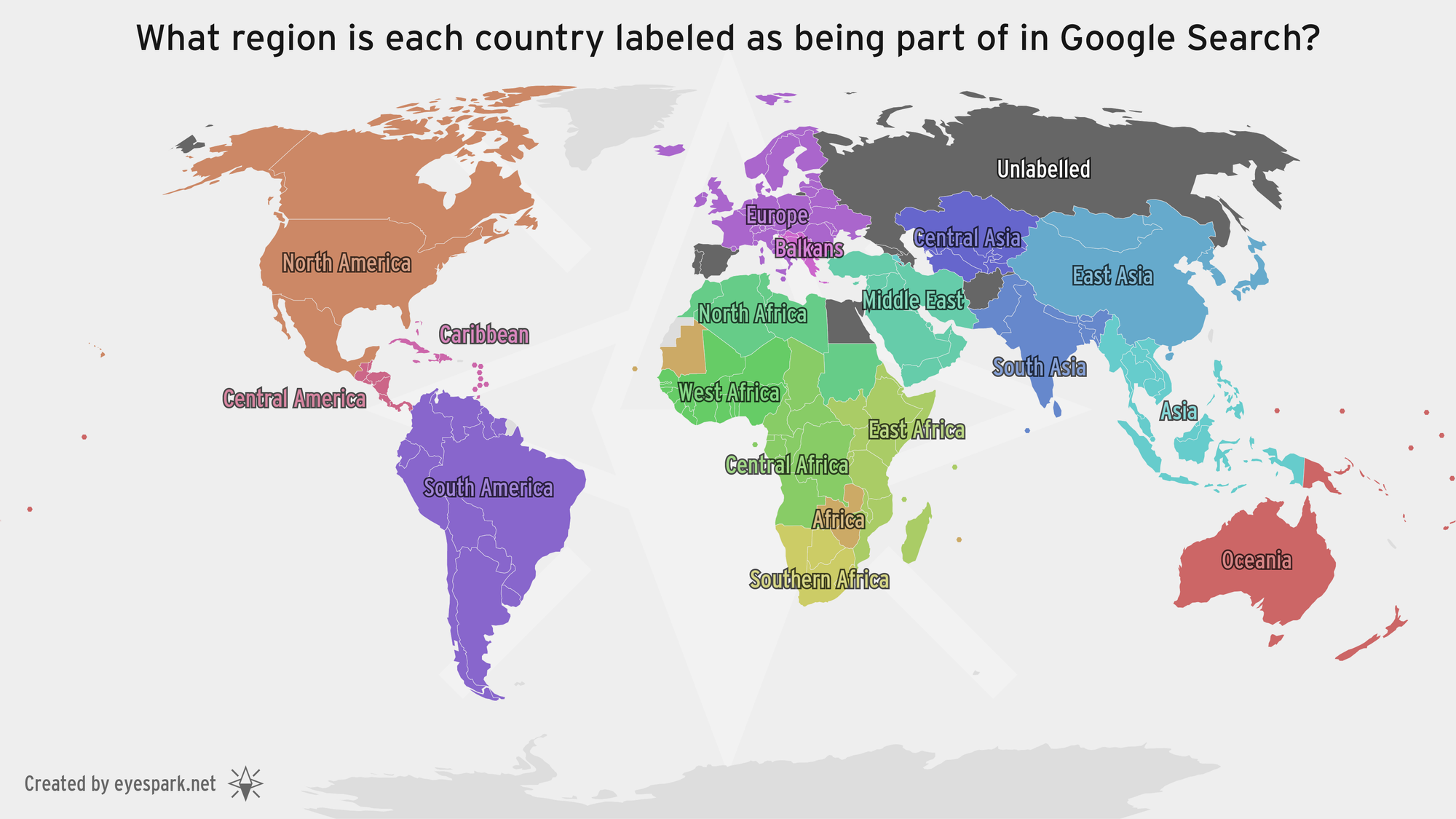
Seven countries are unlabelled. Russia, Egypt, Azerbaijan, and Georgia are among these, and these make sense as they are in some way transcontinental, meaning they have parts in different continents. Spain and Portugal are also included here, which despite being in Europe do have control of some islands in Africa. The strangest is Afghanistan though, which despite being firmly in Asia is in the crossroads of three subregions.
Even stranger, the very transcontinental Türkiye is labelled as firmly belonging to the Middle East, despite having part of its territory in Europe.
The Americas are divided as they are with the UN regions, with North America being used exclusively for Northern America (Canada, the United States and Mexico), with the rest being labelled appropriately as either Central America or the Caribbean. South America remains in one piece, and same with Oceania.
With the exception of the unlabelled countries mentioned earlier, Europe is split in two regions: the Balkans, and not the Balkans (simply labelled as Europe).
Most of Asia is divided pretty clearly with the usual regions of the Middle East, Central Asia, South Asia and East Asia, however Southeast Asia is simply labelled as “Asia”. Additionally Armenia is also just labelled as “Asia”, making it one of only two countries (excluding islands) to not border any other countries with its same label.
Africa, however, is by far the craziest. Central Africa, East Africa, and Southern Africa are all fairly accurate with the notable exception of Zimbabwe and Zambia right in between the three of them, which are simply labelled as “Africa”. Also labelled as just “Africa” is Mauritania, found right in between North Africa and West Africa, which is the other country which does not border any country with the same label. The island nations of Cabo Verde and Mauritius are also labelled as just "Africa".
And that’s it! Once again this was a very simple project, but it ended up with some very interesting observations. I don't really know if Google gets these labels from a more specific source, if anybody knows please let me know! But regardless, this was still a very fun project to make and learn about!